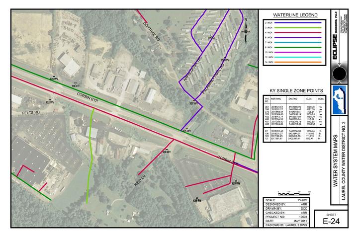
Laurel County Water District No. 2 (LCWD) serves water to approximately 6,000 industrial, commercial, and residential customers. Included in their system is over 700 valves and over 150 fire hydrants in a service area that is approximately 30 square miles. In the past, LCWD had used an old mylar drawing and a limited number of project record drawing plans to record data and locations of these items in their system. Without any overall accurate, reproducible plans, LCWD wanted to map the system with GPS.
In the Spring of 2011, Eclipse Engineers mapped all of LCWD’s valves and fire hydrants using a survey grade, real time kinetic (RTK) GPS rover system. This GPS unit is accurate to less than 1 inch horizontally and 1 inch vertically, unlike mapping grade equipment that is typically within 3 to 6 feet horizontally and 6 to 12 feet vertically. The equipment requires only one person to operate a rover receiver with data collector. No base station is needed as the Kentucky Transportation Cabinet’s VRS system provides a free, base station grid across all of Kentucky that can be accessed very easily. In the past, a separate base station receiver was needed to operate survey grade equipment. This added time in the field and limited the range of the rover.
After gathering this raw data, the points were plotted on top of an aerial map to scale, and on KY State Plane Coordinates. The original scope of mapping and plotting was completed in approximately 150 hours of total work, including field and office time. From here LCWD can use this data in many ways. By adding waterlines to the digital maps, LCWD could use this information to serve as base data for any future capital projects. They could also conduct a hydraulic model from this to-scale information. LCWD could also have a survey grade GIS system in which they could add and manage data digitally for work orders and historical data, always having the ability to add data in the future.
If LCWD chooses to purchase a survey grade GPS system, they could find water valves that have been paved over or are covered in snow in the middle of the night. After this work is fully complete, LCWD will have an accurate map of their water system and will be able to use the accuracy of this data in a way that most water utilities with outdated mapping cannot.